
Catchments
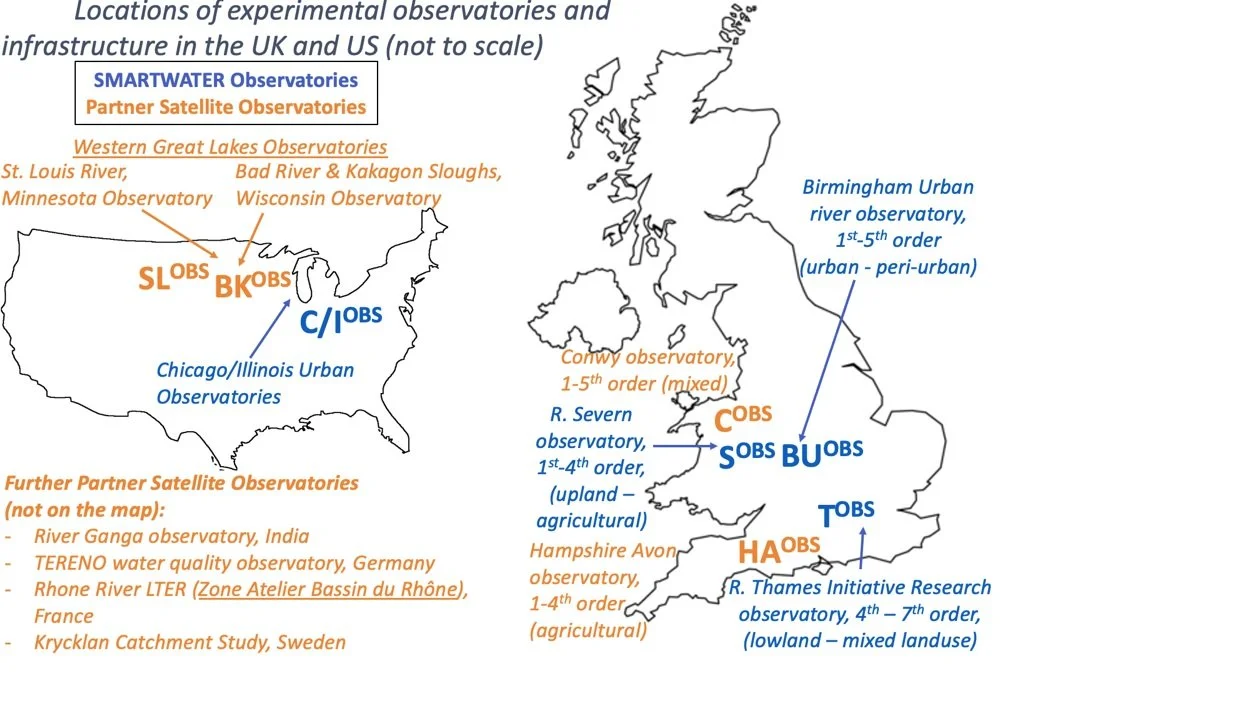
SMARTWATER’s ambitious vision will be achieved by leveraging a significant body of prior and ongoing work by the investigators and partners. Through project co-creation we will improve plans for adaptation, mitigation and detection of risks arising from multi-pollution pressures under changing climate and catchment (land use) conditions. Together, we have developed critical research assets that form the foundations for enabling the successful delivery of this comprehensive project. The project will benefit from experimental infrastructure and data archives of our four major catchment observatories established and run by the consortium and an additional seven partner satellite observatories.
All Catchments
Catchments consist of primary observatories (Birmingham Urban, BIFoR Rural, Thames, and NU), alongside satellite observatories, with prior data accessible through partner organisations.
-
Birmingham Urban Catchment Observatory (since 2019): comprising nested catchments of urban headwater streams (1-4th order) of the Trent with continuous in-situ water quality observations and event-based auto-sampling covering diverse urban and peri-urban land cover types.
-
BIFoR Rural Water Quality Observatory (since 2015): Catchment observatory comprising network of 1-5th order streams of the Severn with continuous monitoring of agricultural pollutants (nutrients, organic and faecal matter, sediment, pesticides) under changing land use and management.
-
Thames Initiative Research Observatory (since 2009): Nested sampling sites along Thames River (high order) and major tributaries monitored weekly for water quality and microbiology. Thames automatic monitoring station (by UKCEH and EA) producing hourly total P, dissolved P, nitrate, ammonium, DO, chlorophyll, turbidity, pH, conductivity, temperature).
-
NU Chicago-Illinois Observatory (since 2015): Network of urban green infrastructure and river sites in highly urbanized waterways in the Little Calumet River and Chicago River watersheds. Continuous monitoring of surface and groundwater levels, temperature, and EC, and extensive data on metals and phosphorus in water, soil and sediments from monthly sampling. Now part of the larger CROCUS Urban Integrated Field Laboratory in Chicago ($25M US DOE project, funded Oct. 2022).
-
Hampshire Avon Observatory, UK (since 2010): 5 sites with high-resolution monitoring infrastructure from Defra DTC (Joint-PI Johnes) and NERC DOMAINE Large Grant (2014-2019, PI Johnes)
-
Conwy observatory, UK (since 2012): Long-term paired pollution (nutrient speciation, DO, T, EC) data for 3 sites, established in NERC Macronutrient Cycles and DOMAINE Large Grant programmes.
-
Western Great Lakes Observatory (St. Louis River (MN) & Bad River/Kakagon Sloughs (WI)), US: Regional CoPe Hub with SAGE-enabled water quality sensor networks, NOAA, USGS, tribal data.
-
River Ganga observatories, India: Long-term monitoring of key water quality parameters (EC, turbidity, DO) at >30 sites, host of proxy water quality indicator sensor network testing.
-
Rhone LTER (Zone Atelier Bassin du Rhône), CH/France: Continuous water quality monitoring in 11 tributaries from Alps to Mediterranean, incl. Urban Hydrology Observatory Lyon
-
TERENO observatory, Germany: Network of high-frequency water quality sensors (incl. in-situ
fluorescence, UV absorbance for nutrient speciation) along a gradient of anthropogenic impacts
-
Krycklan Catchment Study, Sweden: In-situ fluorescence and UV absorbance for nutrient and DOM characterisation in 12 nested river catchments, high-frequency contaminant sampling